

 User Notice
 Forum Links
The January 23rd 1999 Severe Weather Outbreak
Looking back 25 years ago
Looking back 25 years ago
Related Threads
Coming Soon
Thread Information
Views
67
Replies
0
Rating
0
Status
OPEN
Thread
Creator
Creator
tornadocam
01-23-24 08:31 PM
01-23-24 08:31 PM
Last
Post
Post
tornadocam
01-23-24 08:31 PM
01-23-24 08:31 PM
Views: 55
Today: 0
Users: 1 unique
Today: 0
Users: 1 unique
Thread Actions


Order
The January 23rd 1999 Severe Weather Outbreak
01-23-24 08:31 PM
tornadocam is Offline
| ID: 1407134 | 739 Words
| ID: 1407134 | 739 Words
tornadocam
Level: 103


POSTS: 3066/3122
POST EXP: 781784
LVL EXP: 11408958
CP: 61424.1
VIZ: 4876874

POSTS: 3066/3122
POST EXP: 781784
LVL EXP: 11408958
CP: 61424.1
VIZ: 4876874
Likes: 0 Dislikes: 0
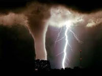
January 23rd 1999 was a very bad day in a lot of southern states in the United States. A very mild winter set the recipe for a severe weather outbreak. On January 23rd one of the worst tornado and severe thunderstorm outbreaks occurred on January 23rd 1999. This event was infamous for long tracked violent tornadoes and lots of straight line wind damage. As a Meteorologist I'm going to be analyzing this event and taking a trip down memory lane. In the Southern United States winter was above average in temperatures. The Winter of 1998/1999 would be above average. One reason was a La Nina developed in 1998. This La Nina would last 3 years. In the Southern Part of the United States La Nina typically causes warmer winters. A few days before January 23rd 1999 temps were in the 60's and 70's in the states of Kentucky, Tennessee, Georgia, Alabama, Mississippi, Arkansas, and Louisiana. For a lot of states the temperatures felt like March instead of January. A powerful storm system was coming out of the Rockies and was supposed to strengthen. I can remember the meteorologists on TV saying this could be bad and we would have to watch this as it was going to be like a March system. On January 22nd in my area I noticed the winds shifted to the south. The dewpoint started to increase and the temperatures started to increase a storm was brewing. The Storm system had warm air ahead of it and ample moisture coming from the Gulf. Behind this storm system was cooler air. Looking back on it now there was enormous amount of wind energy. A 90-100 mph jet was blasting in from the west southwest. Earlier in the day thunderstorms started to develop. The storms started to turn severe and rotate producing several tornadoes. These tornadoes were unusually strong for January. A lot of them ended up being rated EF2 or higher. Tornadoes started touching down in Arkansas, Mississippi, Louisiana, and Alabama. As the afternoon went on more storms started to develop and turn severe. As the storms moved eastward they became linear and formed a squall line. The Squall line started to produce damaging winds 70-80 mph and occasionally tornadoes. My area was in the cross hires of the squall line. I can remember taking notes on weather observations. I could see the low clouds rolling in. Despite being just 14 I knew a lot about meteorology. I had been taking notes and reading meteorology books since I was 3. I did not like what I was seeing. As many of you know I would go on to become an actual meteorologist What was concerning was as the squall line got close to my area it turned dark. This meant there was the potential for severe storms and a few tornadoes in the dark. The squall line moved into my area. Several severe thunderstorm and even a few tornado warnings were issued. The storms were still producing 70 mph winds in my area. Therefore, there was lots of straight line wind damage. Large trees and power lines were done. Homes had roof damage. In other states the next day revealed the destruction of the tornadoes. A lot of communities were severely damaged. In some towns only the foundations were left were homes once stood. Overall, this event produced 128 tornadoes, and over 200 straight line wind reports. Several of the tornadoes were EF2 or higher tornadoes. Arkansas and Mississippi had EF3 and EF4 type tornadoes. This event was historic due to the amount of tornadoes produced in January. Sadly, 9 people lost their lives and millions of dollars was done in damage. As I stated I'm now an actual meteorologist. Looking back it is easy to see why this event was so bad. You had very warm air due to a mild winter and warm air being pushed up from the Gulf. The 90-100 mph jet blasting in created wind energy and enormous amount of wind shear. Then you had the strong low pressure system coming out of the Rockies with cool air behind it. All of these ingredients came together to produce this monster of a storm. Basically, even though it was January you had March like conditions across the south. Arkansas and Mississippi had the strongest amount of wind shear and wind energy. Therefore, that is why these two states had long tracked tornadoes. In the Southern United States winter was above average in temperatures. The Winter of 1998/1999 would be above average. One reason was a La Nina developed in 1998. This La Nina would last 3 years. In the Southern Part of the United States La Nina typically causes warmer winters. A few days before January 23rd 1999 temps were in the 60's and 70's in the states of Kentucky, Tennessee, Georgia, Alabama, Mississippi, Arkansas, and Louisiana. For a lot of states the temperatures felt like March instead of January. A powerful storm system was coming out of the Rockies and was supposed to strengthen. I can remember the meteorologists on TV saying this could be bad and we would have to watch this as it was going to be like a March system. On January 22nd in my area I noticed the winds shifted to the south. The dewpoint started to increase and the temperatures started to increase a storm was brewing. The Storm system had warm air ahead of it and ample moisture coming from the Gulf. Behind this storm system was cooler air. Looking back on it now there was enormous amount of wind energy. A 90-100 mph jet was blasting in from the west southwest. Earlier in the day thunderstorms started to develop. The storms started to turn severe and rotate producing several tornadoes. These tornadoes were unusually strong for January. A lot of them ended up being rated EF2 or higher. Tornadoes started touching down in Arkansas, Mississippi, Louisiana, and Alabama. As the afternoon went on more storms started to develop and turn severe. As the storms moved eastward they became linear and formed a squall line. The Squall line started to produce damaging winds 70-80 mph and occasionally tornadoes. My area was in the cross hires of the squall line. I can remember taking notes on weather observations. I could see the low clouds rolling in. Despite being just 14 I knew a lot about meteorology. I had been taking notes and reading meteorology books since I was 3. I did not like what I was seeing. As many of you know I would go on to become an actual meteorologist What was concerning was as the squall line got close to my area it turned dark. This meant there was the potential for severe storms and a few tornadoes in the dark. The squall line moved into my area. Several severe thunderstorm and even a few tornado warnings were issued. The storms were still producing 70 mph winds in my area. Therefore, there was lots of straight line wind damage. Large trees and power lines were done. Homes had roof damage. In other states the next day revealed the destruction of the tornadoes. A lot of communities were severely damaged. In some towns only the foundations were left were homes once stood. Overall, this event produced 128 tornadoes, and over 200 straight line wind reports. Several of the tornadoes were EF2 or higher tornadoes. Arkansas and Mississippi had EF3 and EF4 type tornadoes. This event was historic due to the amount of tornadoes produced in January. Sadly, 9 people lost their lives and millions of dollars was done in damage. As I stated I'm now an actual meteorologist. Looking back it is easy to see why this event was so bad. You had very warm air due to a mild winter and warm air being pushed up from the Gulf. The 90-100 mph jet blasting in created wind energy and enormous amount of wind shear. Then you had the strong low pressure system coming out of the Rockies with cool air behind it. All of these ingredients came together to produce this monster of a storm. Basically, even though it was January you had March like conditions across the south. Arkansas and Mississippi had the strongest amount of wind shear and wind energy. Therefore, that is why these two states had long tracked tornadoes. |
Vizzed Elite
Affected by 'Laziness Syndrome'
Registered: 08-18-12
Last Post: 91 days
Last Active: 38 days
Affected by 'Laziness Syndrome'
Registered: 08-18-12
Last Post: 91 days
Last Active: 38 days
