January 21st and 22nd will soon be here. Normally, in the South January has overcast days, cool temperatures, and often rain. However, 14 years ago that was not the case. Instead a severe weather outbreak unfolded. This event also occurred on my birthday. It was also occurring when I was just finishing up my degree and about to be a meteorologist. So, lets take a road down memory lane 14 years ago.
In 2010 I was just recovering from brain surgery. the first half of January 2010 was very cold. After January 15th the pattern flipped. Highs were in the 60's. As a student I was looking at charts and noticed a strong storm system was expected to develop around January 20th. I noticed that this storm system had wind energy. Being a student and about to graduate I knew that the ingredients were coming together for a significant storm system.
On January 19th the models and charts were not painting a pretty picture. The storm system would impact the Southern United States mainly the states of Louisiana, Arkansas, Eastern Texas and then spread into Mississippi, Alabama, Kentucky, Tennessee, and Georgia. What had me the most concerned was the amount of wind energy this system had. An 80 mph jet was blasting into this storm system providing wind energy. There was warm air at the surface as temps were in the 60's and 70's. In addition, there was a huge surge of moisture being supplied by the Gulf and cold air behind it. On January 20th the models were showing individual super cell storms then the storms were to become linear and form a squall line.
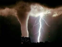
On the 21st storms started to quickly develop. When temps started to rise the storms started to tap into the wind energy and wind shear at the surface. The storms started to rotate and produce tornadoes. During the evening the storms became linear as expected and form a squall line. The Squall line extended from Central Kentucky to North Alabama. As the storms moved eastward they started to produce 70-80 mph damaging winds and continued to produce tornadoes.
My area was hit with the squall line. Just to the east of me two tornadoes were produced by the line of thunderstorms. However, my county saw the 70 mph straight line winds. There were widespread reports of wind damage, large trees down, power lines down or broken, and roof damage.
Overall 25 tornadoes were confirmed, and several reports of damaging straight line winds. There were several reasons I will never forget this event. First, it was on my birthday. Second, I was recovering from major surgery, and third I was about to be a meteorologist. Even though I was going to be a Meteorologist I was not going to be on TV. This event inspired me to start my own weather page on facebook were I would post warnings and my own forecasts.
Looking back on this event 14 years ago its easy to see why it was so potent. Above average temperatures, moisture from the Gulf of Mexico, wind shear, and the 80 mph jet in the atmosphere provided all the ingredients for a widespread severe weather outbreak.
Also, this event started a series of severe weather outbreaks that would plague the Southern United States all the way till June. Basically, this event was the start of a very storm year. One reason 2010 could have been stormy was it was a transition year. 2009's El Nino had faded by March and La Nina started to rapidly develop. The 2010 La Nina would last till 2012. Moreover, this La NIna was infamous for destructive tornado outbreaks in the South and Midwest regions of the United States for two years.
January 21st and 22nd will soon be here. Normally, in the South January has overcast days, cool temperatures, and often rain. However, 14 years ago that was not the case. Instead a severe weather outbreak unfolded. This event also occurred on my birthday. It was also occurring when I was just finishing up my degree and about to be a meteorologist. So, lets take a road down memory lane 14 years ago.
In 2010 I was just recovering from brain surgery. the first half of January 2010 was very cold. After January 15th the pattern flipped. Highs were in the 60's. As a student I was looking at charts and noticed a strong storm system was expected to develop around January 20th. I noticed that this storm system had wind energy. Being a student and about to graduate I knew that the ingredients were coming together for a significant storm system.
On January 19th the models and charts were not painting a pretty picture. The storm system would impact the Southern United States mainly the states of Louisiana, Arkansas, Eastern Texas and then spread into Mississippi, Alabama, Kentucky, Tennessee, and Georgia. What had me the most concerned was the amount of wind energy this system had. An 80 mph jet was blasting into this storm system providing wind energy. There was warm air at the surface as temps were in the 60's and 70's. In addition, there was a huge surge of moisture being supplied by the Gulf and cold air behind it. On January 20th the models were showing individual super cell storms then the storms were to become linear and form a squall line.
On the 21st storms started to quickly develop. When temps started to rise the storms started to tap into the wind energy and wind shear at the surface. The storms started to rotate and produce tornadoes. During the evening the storms became linear as expected and form a squall line. The Squall line extended from Central Kentucky to North Alabama. As the storms moved eastward they started to produce 70-80 mph damaging winds and continued to produce tornadoes.
My area was hit with the squall line. Just to the east of me two tornadoes were produced by the line of thunderstorms. However, my county saw the 70 mph straight line winds. There were widespread reports of wind damage, large trees down, power lines down or broken, and roof damage.
Overall 25 tornadoes were confirmed, and several reports of damaging straight line winds. There were several reasons I will never forget this event. First, it was on my birthday. Second, I was recovering from major surgery, and third I was about to be a meteorologist. Even though I was going to be a Meteorologist I was not going to be on TV. This event inspired me to start my own weather page on facebook were I would post warnings and my own forecasts.
Looking back on this event 14 years ago its easy to see why it was so potent. Above average temperatures, moisture from the Gulf of Mexico, wind shear, and the 80 mph jet in the atmosphere provided all the ingredients for a widespread severe weather outbreak.
Also, this event started a series of severe weather outbreaks that would plague the Southern United States all the way till June. Basically, this event was the start of a very storm year. One reason 2010 could have been stormy was it was a transition year. 2009's El Nino had faded by March and La Nina started to rapidly develop. The 2010 La Nina would last till 2012. Moreover, this La NIna was infamous for destructive tornado outbreaks in the South and Midwest regions of the United States for two years.


 User Notice