I was gone for most of the day yesterday, so I did not get to post this. I decided I would look back on an event that occurred 8 years ago. The Derecho of July 14th 2015. This was an event that I witnessed and hit my area hard.
The Derecho of the 14th was the second Derecho in less than 48 hours. The first Derecho occurred on the 13th. Before, I go any further, I think it is important to define what a Derecho is. A squall line is a line of severe storms that has damaging winds and occasionally tornadoes. Well, a Derecho is a type of squall line. Derechos are fast moving squall lines that cover hundreds of miles in a short amount of time. In addition, the thunderstorms in a Derecho have winds over 75 mph. Like regular Squall lines Derechos can produce tornadoes. Due to the high winds sometimes this event is referred to as the land Hurricane.
On July 13th 2015. The First Derecho formed in Minnesota and started to move southeastward. The Storms would eventually make into Illinois. Several tornadoes occurred and winds from the thunderstorms were over 80 mph.
On the 13th I remember talking on my weather page (as I'm a meteorologist just not on TV) how I was concerned about a Derecho event for my area. The ingredients were coming together. It was very hot at the surface with temps in the 90's, but there was cold air aloft. This meant you had cool and hot air colliding. Moreover, you had a frontal system with 90 mph winds in the mid-levels behind the hot air. Furthermore, you had a strong jet blasting in from the west. There was also pockets of wind shear.I remember saying I hope I'm wrong on this forecast but I do not like what I am seeing. I stated how all warnings would need to be taken seriously as we would likely have a Drecho event. I explained how we could be dealing with a few tornadoes and mostly storms with 75 mph plus winds.
On the 14th the Storm Prediction Center put the following areas: Southern Ohio, West Virginia, Central/East Kentucky, Central/East Tennessee, North Alabama, North Georgia, and the upper part of South Carolina under the Enhanced Risk. Then Severe Thunderstorm Watches started to be issued. These watches were tagged for thunderstorms with 75 mph plus winds and a few tornadoes.
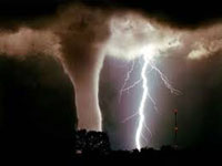
Storms started to rapidly develop in Indiana and started to move southeast. As the storms moved southeast they developed into a line and rapidly intensified. As the storms moved into Kentucky, Tennessee, North Alabama, and North Georgia they intensified to their peak strength. The Thunderstorms were producing winds 80-90 mph. Then some of the storms started to rotate and produce tornadoes.
The Storms hit my area (Knoxville TN to Rome Georgia) very hard. The winds in the thunderstorms snapped large trees, power lines, did roof damage to homes. A tornado also occurred in my area. This tornado would be rated EF1 with winds of 100 mph. The National Weather Service estimated the winds to be 85 mph from the thunderstorms. Several thousands of people were out of power.
I continued to post warnings on my weather page and keep people updated until the storms moved over my house. At my house I personally measured a wind guest up to 63 mph. I could see outside the power lines bending and the trees moving back and forth. The wind was really howling. Thankfully the higher winds missed my area. I did not lose any trees. Just a few miles around me it was a different story with trees and power lines down as well as roof damage to houses. Still, my house lost power. We were without power for several hours.
Then another problem started to occur. These storms also had high precipitation. Some of the storms produced rainfall rates of 0.5-1 inch of rain an hour. Flooding started to occur in some spots due to the high amount of rainfall in a short amount of time.
Eventually the Derecho that started in Indiana made it all the way to Greenville South Carolina in 24 hours. It left a lot of destruction in its path from the thunderstorms and tornadoes it produced. My area was the epicenter of the strongest storms. It took several days for crews to clean up the debris, restore the power lines and remove the trees down.
My area has had several events like this since then as well as tornado outbreaks. But since it was the 8 year anniversary of this event. I figured I would do a post/thread of this event.
I was gone for most of the day yesterday, so I did not get to post this. I decided I would look back on an event that occurred 8 years ago. The Derecho of July 14th 2015. This was an event that I witnessed and hit my area hard.
The Derecho of the 14th was the second Derecho in less than 48 hours. The first Derecho occurred on the 13th. Before, I go any further, I think it is important to define what a Derecho is. A squall line is a line of severe storms that has damaging winds and occasionally tornadoes. Well, a Derecho is a type of squall line. Derechos are fast moving squall lines that cover hundreds of miles in a short amount of time. In addition, the thunderstorms in a Derecho have winds over 75 mph. Like regular Squall lines Derechos can produce tornadoes. Due to the high winds sometimes this event is referred to as the land Hurricane.
On July 13th 2015. The First Derecho formed in Minnesota and started to move southeastward. The Storms would eventually make into Illinois. Several tornadoes occurred and winds from the thunderstorms were over 80 mph.
On the 13th I remember talking on my weather page (as I'm a meteorologist just not on TV) how I was concerned about a Derecho event for my area. The ingredients were coming together. It was very hot at the surface with temps in the 90's, but there was cold air aloft. This meant you had cool and hot air colliding. Moreover, you had a frontal system with 90 mph winds in the mid-levels behind the hot air. Furthermore, you had a strong jet blasting in from the west. There was also pockets of wind shear.I remember saying I hope I'm wrong on this forecast but I do not like what I am seeing. I stated how all warnings would need to be taken seriously as we would likely have a Drecho event. I explained how we could be dealing with a few tornadoes and mostly storms with 75 mph plus winds.
On the 14th the Storm Prediction Center put the following areas: Southern Ohio, West Virginia, Central/East Kentucky, Central/East Tennessee, North Alabama, North Georgia, and the upper part of South Carolina under the Enhanced Risk. Then Severe Thunderstorm Watches started to be issued. These watches were tagged for thunderstorms with 75 mph plus winds and a few tornadoes.
Storms started to rapidly develop in Indiana and started to move southeast. As the storms moved southeast they developed into a line and rapidly intensified. As the storms moved into Kentucky, Tennessee, North Alabama, and North Georgia they intensified to their peak strength. The Thunderstorms were producing winds 80-90 mph. Then some of the storms started to rotate and produce tornadoes.
The Storms hit my area (Knoxville TN to Rome Georgia) very hard. The winds in the thunderstorms snapped large trees, power lines, did roof damage to homes. A tornado also occurred in my area. This tornado would be rated EF1 with winds of 100 mph. The National Weather Service estimated the winds to be 85 mph from the thunderstorms. Several thousands of people were out of power.
I continued to post warnings on my weather page and keep people updated until the storms moved over my house. At my house I personally measured a wind guest up to 63 mph. I could see outside the power lines bending and the trees moving back and forth. The wind was really howling. Thankfully the higher winds missed my area. I did not lose any trees. Just a few miles around me it was a different story with trees and power lines down as well as roof damage to houses. Still, my house lost power. We were without power for several hours.
Then another problem started to occur. These storms also had high precipitation. Some of the storms produced rainfall rates of 0.5-1 inch of rain an hour. Flooding started to occur in some spots due to the high amount of rainfall in a short amount of time.
Eventually the Derecho that started in Indiana made it all the way to Greenville South Carolina in 24 hours. It left a lot of destruction in its path from the thunderstorms and tornadoes it produced. My area was the epicenter of the strongest storms. It took several days for crews to clean up the debris, restore the power lines and remove the trees down.
My area has had several events like this since then as well as tornado outbreaks. But since it was the 8 year anniversary of this event. I figured I would do a post/thread of this event.


 User Notice